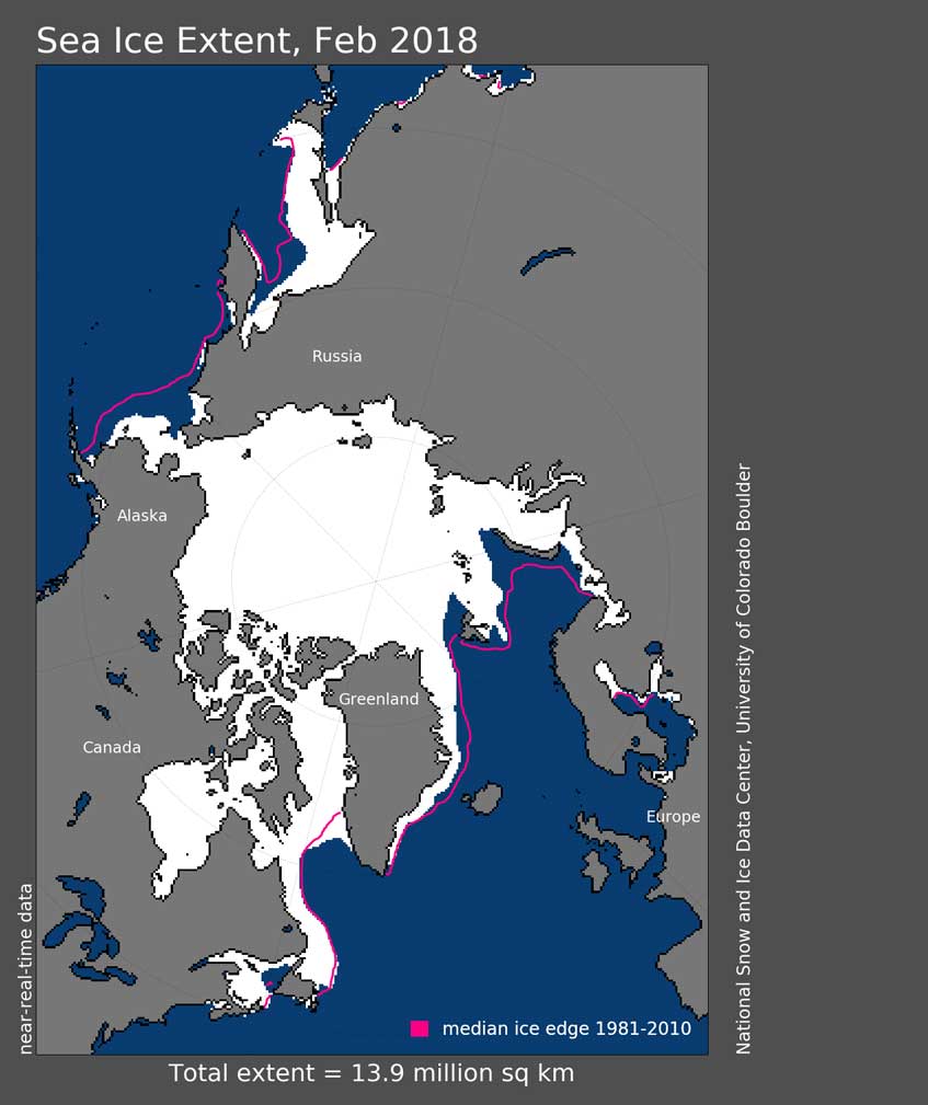
The National Snow and Ice Data Centre have issued their early March update for Arctic sea ice news. The content is not exactly a surprise. Below I’ve laid out some of the details.
Highlights
- Temperatures over the Arctic have been unseasonably high and have been approaching melting point – in February – a time when the grip of winter should be holding fast
- Arctic sea ice extent has hit record lows again. This has been true for both the Atlantic and also the Pacific sides of the Arctic. Areas of open water expanded rapidly in the Bering Sea during the later half of the month.
- An oil tanker has traversed the Arctic Northern Sea route for the very first time in History – in February.
Record Breaking Sea Ice extent lows for February
The last time there was a record low in February was last year, and now February 2018 has hit another record low.
Arctic sea ice extent for February 2018 averaged 13.95 million square kilometers (5.39 million square miles). This is the lowest monthly average recorded for February, 1.35 million square kilometers (521,000 square miles) below the 1981 to 2010 average and 160,000 square kilometers (62,000) below the previous record low monthly average in 2017.
This is all part of an ongoing ever present downwards trend. The linear rate of decline for February is 47,000 square kilometers per year (18,000 square miles per year), or 3.1 percent per decade.
New Shipping Routes
The idea of being able to sail across the Arctic in summer is old news. What is new is the idea of being able to do this in winter.
Most of the new commercial shipping traffic has been during summer, primarily through the Northern Sea Route along the coast of Siberia. However, this February a commercial tanker, the Eduard Toll, made the first crossing of the Northern Sea Route in winter.
This is the first time a tanker has crossed the #Arctic in winter unassisted https://t.co/Zof7fbrOM0 #environment pic.twitter.com/CyLg4SjkHl
— World Economic Forum (@wef) March 7, 2018
One important clarification is required here, this is not simply about less sea ice. Improvements in ship-building and the development of ice-strengthened hull technology was also a major factor in enabling winter access. Previous ice-strengthened ships could only navigate safely through 0.5 meter thick ice, compared to the 1.8 meter thick ice that the Eduard Toll cruised through.
But less sea ice is part of this story …
Sea Ice extent did also play a very decisive role in this story.
While the Northern Sea Route has tended to be dominated by first-year ice, which typically reaches a maximum of around 2 meters, the thicker (3- to 4-meter) multi-year ice would be a hazard even to the newer, stronger ships. According to analysis by the U.S. National Ice Center, this year’s old ice (multi-year ice – marked Brown in the above diagram) has pulled completely away from the coast and the Northern Sea Route is dominated by first-year medium (0.7- to 1.2-meter) or first-year thick (1.2- to 2-meter) ice. This, in conjunction with improvements in ship-construction, is what has made the Northern Sea route possible for the first time in the depths of the Arctic winter.
Now that this has been proven to be viable, a fleet of six ships with similar technology is being constructed by a South Korean shipbuilder.
Winter Warming Trends
This is the third winter in a row in which extreme heat waves have been recorded over the Arctic Ocean. A study published last year by Robert Graham from the Norwegian Polar Institute showed that recent warm winters represent a trend towards increased duration and intensity of winter warming events within the central Arctic.
Increasing frequency and duration of Arctic winter warming events. Geophysical Research Letters 44: 6974–6983.
DOI:10.1002/2017GL073395
While the Arctic has been relatively warm for this time of year, northern Europe was hit by extreme cold conditions at the end of February.
What has been happening?
Pacific side
Low pressure centered just east of the Kamchatka Peninsula and high pressure centered over Alaska and the Yukon during February set up southerly winds that brought warm air and warm ocean waters into the Pacific side of the Arctic Ocean, impeding southward ice growth. This helps to explain the rapid loss of ice extent in the Bering Sea and the ice-free regions within the Chukchi Sea during the month. The warm air intrusion is evident in the 925 mb air temperatures, with monthly temperatures 10 to 12 degrees Celsius (18 to 22 degrees Fahrenheit) above average in the Chukchi and Bering Sea.
Atlantic Side
On the Atlantic side, low pressure off the southeast coast of Greenland and high pressure over northern Eurasia helped to funnel warm winds into the region and may have also enhanced the northward transport of oceanic heat. At the end of the month, this atmospheric circulation pattern was particularly strong, associated with a remarkable inflow of warm air from the south, raising the temperatures near the North Pole to above freezing, around 20 to 30 degrees Celsius (36 to 54 degrees Fahrenheit) above average. Air temperatures at Cape Morris Jesup in northern Greenland (83°37’N, 33°22’W) exceeded 0 degrees Celsius for several hours and open water formed to the north of Greenland at the end of the month.
Tweets
https://twitter.com/NSIDC/status/971073241967091713
https://twitter.com/ENVWEST/status/971270776333787137
https://twitter.com/ENVWEST/status/971263625720684544
