There he wrote …
Pre-Christmas melt? North Pole forecast to warm 50 degrees above normal Thursday
It’s not normal, and it’s happening again.
For the second year in a row in late December and for the second time in as many months, temperatures in the high Arctic will be freakishly high compared to normal.
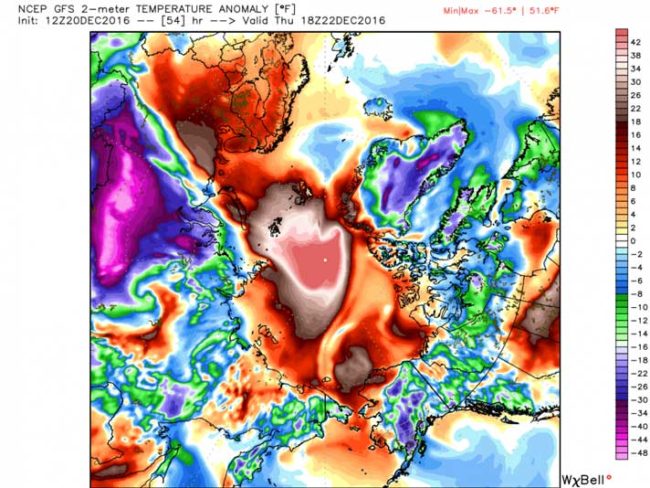
Computer models project that on Thursday, three days before Christmas, the temperature near the North Pole will be an astronomical 40-50 degrees warmer-than-normal and approaching 32 degrees, the melting point.
The weird can be part of ‘Normal’. Is this a departure from that?
It can normally happen, freak events like this are part of the variability of weather. It happened last December, and looking further back it happens once or even twice every decade.
In response to the December 2015 Arctic warming event a paper was written to examine the topic and then published in Nature only a few weeks ago.
Here we use buoy and radiosonde data along with operational weather forecasts and atmospheric reanalyses to show that such events are associated with surface cyclones near the pole as well as a highly perturbed polar vortex. They occur once or twice each decade with the earliest identified event taking place in 1959.
There is a “but” there because that pattern seeking engine sitting between our ears really helps us to spot a trend. The paper does also point this out that such events will potentially become more frequent because of climate change …
the warmest midwinter temperatures at the North Pole have been increasing at a rate that is twice as large as that for mean midwinter temperatures at the pole. It is argued that this enhanced trend is consistent with the loss of winter sea ice from the Nordic Seas that moves the reservoir of warm air over this region northwards making it easier for weather systems to transport this heat polewards.
… and that increase in such a frequency is what we appear to be witnessing.
So this has not happened since Dec 2015, is that correct?
Nope, this last happened just one month ago in November, and now once again is happening today (Dec 22).
Impressive… model guidance (eg, GFS) indicating surface air temperatures hovering just below freezing at the #NorthPole later this week pic.twitter.com/VN1chMSvu0
— Zack Labe (@ZLabe) December 20, 2016
It basically plays out like this.
- Climate change leads to warming
- Within an Arctic context that leads to the on-going loss of sea ice
- That lack of ice and more exposure of ocean results in energy from the sun being absorbed by the darker ocean instead of being reflected by white ice back out into space … it also enables warmer air to move north.
- That warmer ocean leads to an acceleration in arctic warming … and … (this bit is still controversial) a destabilisation of the jet stream, hence warm air can more easily push up into the arctic.
OK yes, that’s a tad simplistic. Its complex, very complex and all interconnected, but it does serve to paint a crude picture that describes things for you.
What exactly is happening today?
Mr Samenow explains it very well within his article.
The warmth will be drawn into the Arctic by a powerhouse storm east off Greenland. The European weather model estimates its lowest pressure will be around 945 millibars, which is comparable to many category 3 hurricanes.
“That’s pretty intense,” said Ryan Maue, a meteorologist with WeatherBell Analytics.
European model forecast low pressure center of 946 millibars east of Greenland Wednesday helping draw mild air into the Arctic through the Nordic sea. (WeatherBell.com)
Maue explained that depleted sea ice cover east of the Nordic Sea helps create a passageway for warm air to surge north uninhibited. “You have more real estate available to advect the warm and moist air northward,” he said.
The Cold Air does not just magically vanish
There is basically an epic “Oh Sh*t” moment associated with this. That especially applies if you live in Russia.
If indeed the warm air pushes up North and sits on top of the Arctic, it ends up displacing the mass of cold air that was there by pushing that south. In this case it moves over Siberia.
Whoa Vlad! That's some cold air in central Russia. -60s °F pic.twitter.com/TEmLtehQHi
— Ryan Maue (@RyanMaue) December 20, 2016
But perhaps this image illustrates that displacement a bit better …
To help you grasp that, yes Siberia has a reputation for being cold and -20 would not be abnormal. However, -60 is rather obviously 40 degrees below -20.
Tweets
If you look closely, you can see the moisture intrusion into the Arctic in last 24 hours (MIMIC-TPW2 by @UWCIMSS at https://t.co/7wgdJNdWFH) pic.twitter.com/ar1b86Y0Dk
— Zack Labe (@ZLabe) December 21, 2016
Bizarre North Pole temperatures cap off year of record-setting warmth https://t.co/EO9ILBrxoZ via @YahooNews
— Michael Walsh (@wordsofwalsh) December 21, 2016
Sweaty Santa? Weird warmth forecast at North Pole @capitalweather @RyanMaue @afreedma @NOAA @ZLabe @NSIDC @RutgersU https://t.co/BvFy5Anasf pic.twitter.com/IlzzWLOyNR
— USA TODAY Weather (@usatodayweather) December 21, 2016
Red line is Arctic temps so far this year. Green line is normal. Red line about to spike even higher: https://t.co/JwAXe4G6jk pic.twitter.com/YnHKPXCnP8
— Capital Weather Gang (@capitalweather) December 20, 2016